Creek Restoration Action Strategy
The District utilizes the Creek Restoration Action Strategy (CRAS) to assist with prioritization of projects.
CRAS
The District developed the Creek Restoration Action Strategy (CRAS) to prioritize creek reaches, sub-reaches, or sites, in need of stabilization and/or restoration. The District identified eight categories of importance for project prioritization:
Tier I (measurable variables)
- Infrastructure risk
- Erosion and channel stability
- Ecological benefits
- Water quality
Tier II (socio-economic variables)
- Project cost
- Partnership opportunities
- Watershed benefits
- Public education
These categories were scored using methods developed for each category based on a combination of published studies and reports, erosion inventories, field visits, and scoring sheets from specific methodologies. Final tallies of scores for each category, using a two-tiered ranking system, were used to prioritize sites for restoration/remediation.
Creek Assessment
Staff evaluate streams on a rotational basis or as needed in relation to a concern or proposed projects. Streams are assessed in sections called reaches. Each reach is further divided into subreaches. Open the files below to view the reaches and subreaches.
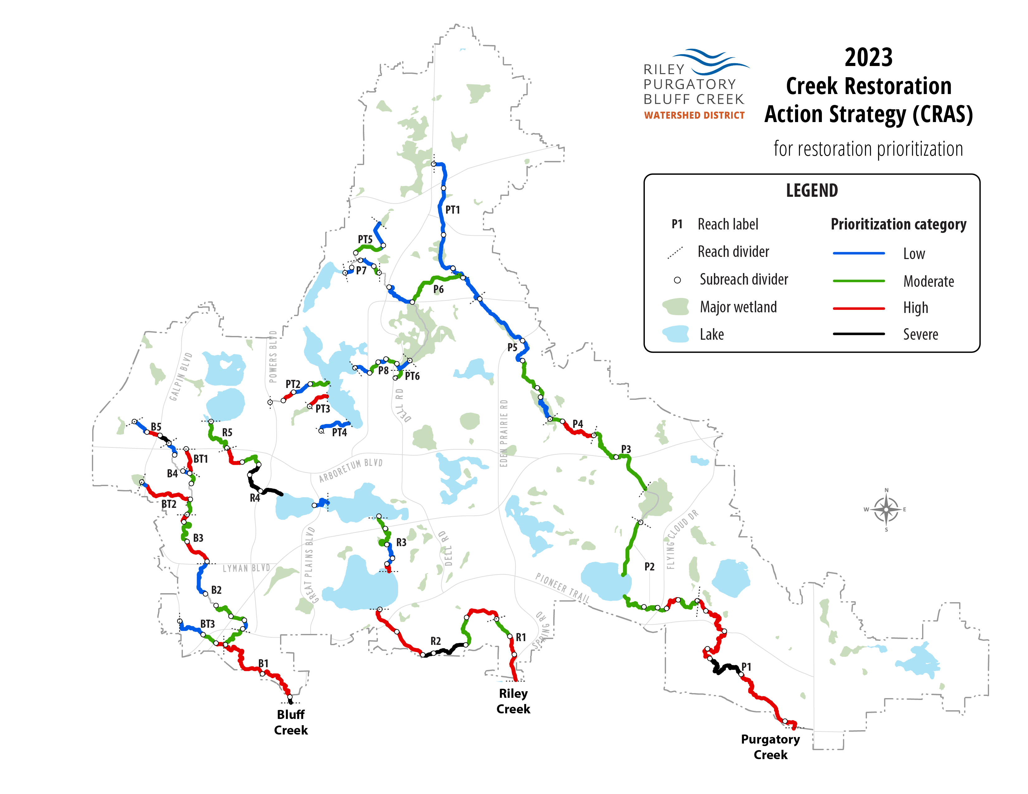
Map of Restoration Priorities
Each year staff reassess a portion of creek subreaches to updated their CRAS scores. The higher the score, the more severe the condition of the creek subreach. The map below shows subreaches color-coded by condition with black being the worst condition. A high CRAS score informs the District's decision to plan and implement an improvement project for that section of creek.
Documents
Read these documents to learn more about CRAS.
- Ranking System for Prioritizing the Implementation of Restoration Projects (2018) - Article about CRAS for the Center for Watershed Protection Association (4 mb)
- Creek Restoration Action Strategy (CRAS): Upper Riley Creek Sediment Source Assessment (2017) (21 mb)
- Final CRAS Report (2017) (6.6 mb)
Related information
Creek Sections of Highest Concern
The table below shows the creek subreaches with the highest CRAS scores. These sections of creek are in the worst condition based upon Tier I and Tier II variables.
| Creek | Reach | Subreach | Location | Tier I Score | Tier II Score | Overall Rank | Restoration Status |
|---|---|---|---|---|---|---|---|
| Riley |
R4 |
R4E |
Powers Blvd to Lake Susan |
22 |
48 |
1 |
Planning |
| Purgatory |
P1 |
P1E |
1,350 feet downstream of Wild Heron Point to Burr Ridge Lane |
22 |
44 |
2 |
-- |
| Riley |
R4 |
R4D |
Railroad Bridge to Powers Blvd |
22 |
44 |
3 |
Planning |
| Riley |
R4 |
R4C |
Park Rd to Railroad Bridge |
22 |
42 |
4 |
Planning |
| Bluff |
B1 |
B1D |
475 feet upstream of Great Plains Blvd to Great Plains Blvd |
24 |
40 |
5 |
-- |
| Bluff |
B5 |
B5C |
Galpin Blvd to West 78th Street |
22 |
40 |
6 |
Planning |
| Riley |
R2 |
R2D |
Upper third between Dell Rd and Eden Prairie Rd |
24 |
36 |
7 |
-- |
| Riley |
R2 |
R2C |
720 feet upstream of Dell Trail to Dell Rd |
22 |
36 |
8 |
-- |